Continue to Site

Welcome to EDAboard.com

Welcome to our site! EDAboard.com is an international Electronics Discussion Forum focused on EDA software, circuits, schematics, books, theory, papers, asic, pld, 8051, DSP, Network, RF, Analog Design, PCB, Service Manuals... and a whole lot more! To participate you need to register. Registration is free. Click here to register now.

Can you explain TRIGONOMETRY equation [HELP]

Status
Not open for further replies.

Rihanna

Junior Member level 1
Joined
Jul 24, 2012
Messages
17
Helped
0
Reputation
0
Reaction score
0
Trophy points
1,281
Activity points
1,396
The signal length from the satellite to the earth station can be found as


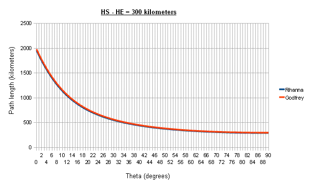
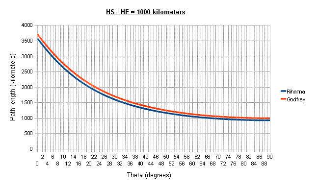
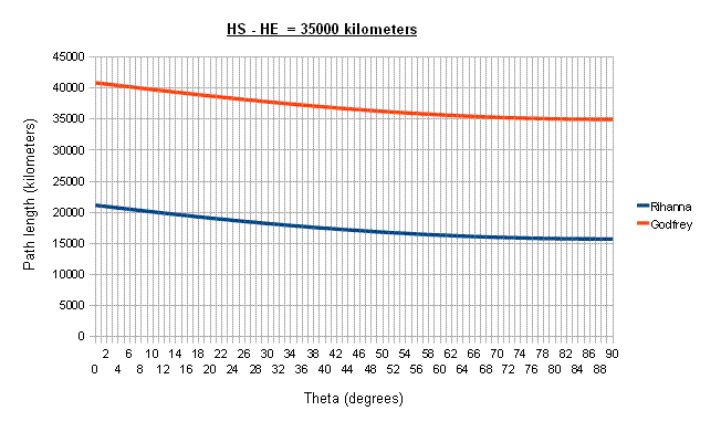
2(hs-he)/[{sin^2(theta)+(2(hs-he)/Re)}^1/2+sin(theta)] if theta < 5 degrees Due to the earth projection

where "hs" is satellite height and "he" is the earth station height and Re is the earth radius=3700 Km

My question is Can you help me to obtain this equation? how they got it?

Regards (y)
 

" help me to obtain this equation? how they got it?........"

From where did u get this equation.. If there is any background for this or any book reference or any website link. then provide it.


This is the correct equation

2(hs-he)/[{sin^2(theta)+(2(hs-he)/Re)}^1/2+sin(theta)]
That seems quite accurate for low earth orbit satellites below about 1000Km, but it's way out for intermediate or high orbit satellites.

I made another spreadsheet comparing this formula to the one I gave in the other thread. I can't absolutely guarantee that my formula is correct, but the results look reasonable. OTOH, this formula is obviously wrong at high altitudes - it gives a path length less than HS - HE.

Here's some results:


P.S. Any answer to abdul's questions?
From where did u get this equation.. If there is any background for this or any book reference or any website link. then provide it.
 

Status
Not open for further replies.

Part and Inventory Search

Welcome to EDABoard.com

Sponsor

Back
Top